EPI Kantoor
The Office of Environmental Planning and Information Management
The Office of Environmental Planning and Information has overall responsibility for national environmental planning, in two ways: (1) in the sense of spatial mapping and zoning of the country based on modern GIS methods, and (2) in the sense of economic planning through the National Environmental Action Planning (NEAP) process. The office also develops and maintains NIMOS’ automated environmental data bases for spatial and non-spatial information. Specifically, the Office carries out the following tasks:
Environmental planning
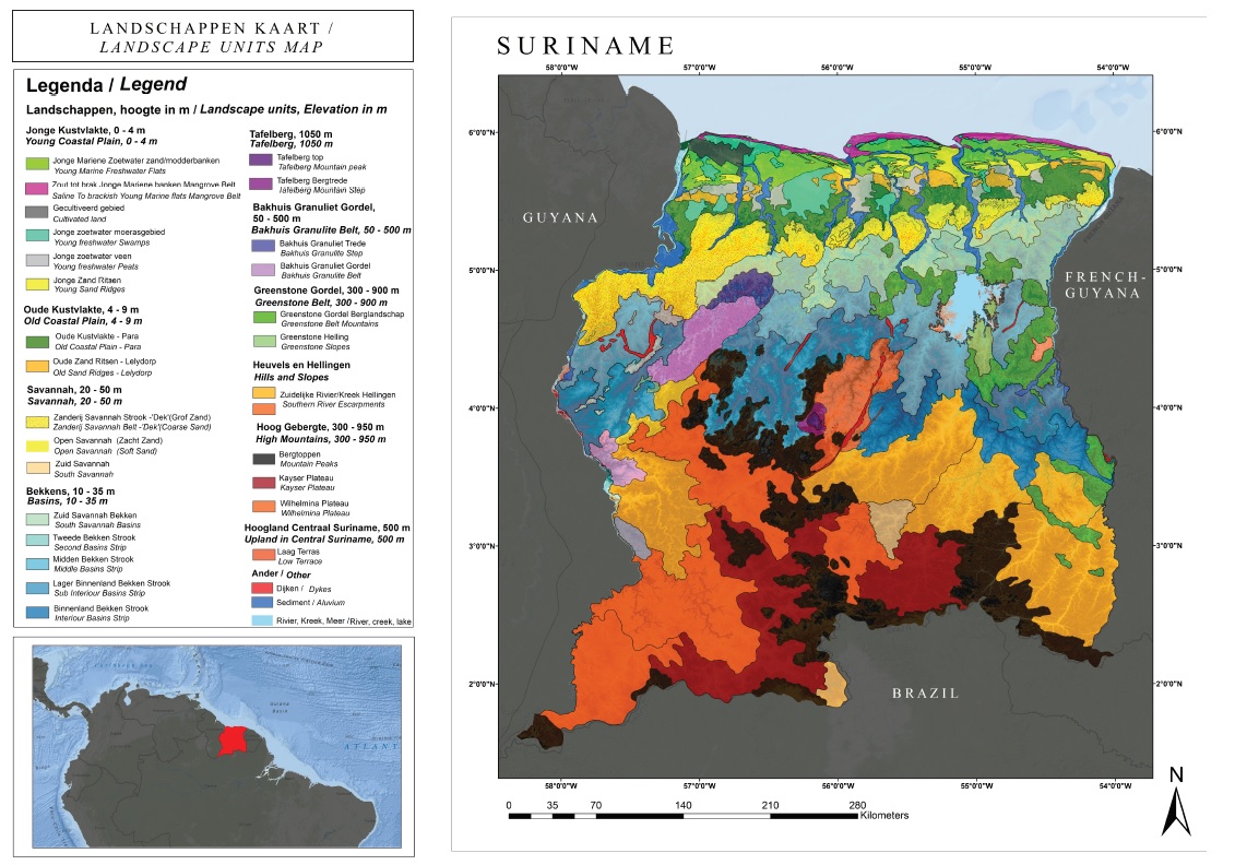
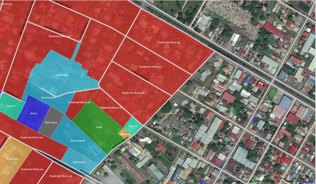
Current land use/land cover information at the national and regional level is needed by many sectoral units as well as for integrated environmental management. The Office will coordinate with current proposed mapping efforts or take primary responsibility for this activity. As part of mapping land cover, satellite image maps should be made available to the sectoral units for carrying out their responsibilities.
The Office, based on soils, forest, wildlife, water resource, and similar information stored on GIS, will provide decision and policy makers with analytical information on the environmental implications of various development projects, will assist in ongoing regional environmental management, resource management, and will provide the rational basis for biodiversity policy making, planning, and management, and ultimately for overall national and regional land use planning. Master plan development for specific resource based sectors, such as mining, agriculture, forestry, and coastal zone development all will benefit from the NIMOS data bases.
The Office, together with NIMOS’ Office of legal services and in cooperation with governmental units in charge of statutory land use planning, will design a program of land use planning in Suriname. The Office, aided by GIS, will develop a national spatial policy, to guide major investments, infrastructure development projects such as major roads, hydro-electric dams, large scale mining operations, major logging concessions, agricultural and urban development.
The Office will develop similar approaches at the regional level and assist in developing regional environmental management concepts and plans. Possible target areas for regional environmental planning and management are:
- The Greenstone Belt
- The Forest Zone
- The coastal zone
- Paramaribo metropolitan area
- Large mining areas before decommissioning and reclamation (Lelydorp)
- Certain river basins
The Office will also manage the National Environmental Action Planning (NEAP) process. The Office will initially update the current National Environmental Action Plan by developing priorities for action and by applying concepts of environmental economics to the planning process.
Environmental information management
There is an excellent collection of base line spatial information for much of Suriname including topographic, soils, geologic, ecological and forest maps or inventories. Much of this information is increasingly difficult for the sector ministries to maintain and disseminate. There is a need to convert these data into digital, GIS, format for effective use. Much of the GIS needs are for the production of basic maps for decision makers.
The existing information is not always complete for the country and is often dated. There is a need to complete coverage’s for some thematic topics and to update much of the data. For environmental management, data from various sectors needs to be integrated, one of the strengths of a GIS.
There are three organizations in Suriname with existing GIS capabilities. These are all functionally outside the government; they are a Non‑Governmental Organization, a consulting firm, and an institute at the University of Suriname. Collectively, these organizations have assembled a useful set of GIS data and considerable expertise. There is considerable interest by a variety of Government units and the international funding organizations in the introduction of GIS capabilities into Suriname. It is conceivable that within the next year up to six different Government units may have initiatives for establishing GIS programs. There is a need for coordination of GIS activities within Suriname.
NIMOS’ Office of Environmental Planning and Information will be responsible for coordinating GIS activities within Suriname. The Office should contain significant GIS capabilities. This is a vital task necessary to establish standardization of hardware and software, coordinate training, create standards for digital data, avoid duplication of data conversion and create open exchange of data.
The Office will identify the kind of data that should be collected, processed, and stored for use in environmental management. For this purpose, the Office will carry out a detail survey of all organizations, research, industry, NGOs and others that are involved in regular monitoring of environmental parameters in Suriname. The Office will seek agreements with all these agencies and bodies, to copy and transfer their data to NIMOS for the national environmental data base. The Office will make major efforts to get data from the private sector and especially from the forestry and mining industry. The Office will be dependent upon data generated in GIS format by the responsible sector groups. NIMOS can assist the sector units by accepting the coordinating GIS responsibility and also by providing support to establish GIS resources within other sectors. In exchange for this support, specific data acquisition or conversion tasks should be specified.
The existing in-country but non-governmental capabilities in GIS should be incorporated in national GIS cooperative actions. This expertise will be helpful in training, as sources of data and in data conversion and analysis. The university should be encouraged to provide training and courses in GIS and related techniques. The Office will design, coordinate, or carry out surveys in areas and with regard to activities for which no knowledge exists and where no monitoring is taking place.
A GIS can only function if it has data. NIMOS must identify, evaluate and acquire digital data as appropriate. Together with the sector units, it must prioritize and assign responsibilities for the conversion of current mapped information or the generation of new data. Thematic and locational environmental issues may determine data priorities. A workshop will be organized to explore the state of the art of environmental data collection and management in Suriname, review existing efforts, identify the gaps, and explore ways of closing them. The workshop will assess constraints such as laboratory equipment, laboratory time, financial resources, professional personnel. Based on workshop findings Office will design a detailed action plan for data collection and environment monitoring.
NIMOS will promote open exchange of data and develop procedures for the availability of digital GIS data. Efforts and policies need to be established to obtain existing digital data and promote future availability. This may require resolving issues of ownership, copyright and value added by agreement or legislation.
Environmental management requires current information especially since many issues are quite dynamic. Remote sensing such as aerial photography coupled with selected field surveys is an excellent method to provide that information. NIMOS should support the Central Bureau of Aerial Surveys (CBL) so they can collect and analyze aerial photographs as necessary. A GPS base station should be established at CBL.
The NIMOS GIS facility should consist of a staff of five with external consultants during the institutional development phase. GIS equipment should be purchased and installed and as necessary provided to selected sector units. Training should be both in-country and external. For full details on the Consultants proposals for GIS development at NIMOS reference is made to Annex 2 on Geographic Information Systems.
In addition to its spatial data bases and GIS system the Office will develop and maintain other environmental data bases. Once systematic data collection systems are put in place, the Office will make major efforts to analyze, store, and report on data collected by all agencies in Suriname. A computerized data base will be established and its data will be available with certain limitations upon authorization by the Office director to scientists and other professionals. A selection of data will be published regularly in the NIMOS newsletter, and an extended version with an analytical summary will be incorporated in NIMOS annual report.

Meet the EPI Office